Airspace Bases
These files contain airspace base freetext for those areas of controlled airspace that 'belong' to an airport (i.e. CTAs). Example for Luton CTA 1:
;CTA 1
2500':N051.57.21.170:W000.07.03.686
Note:
- 2500' is what will appear on the controller's display.
- The apostrophe ' should be appended after any bases that are an altitude.
- The colon : between the airspace base and latitude coordination, and the latitude and longitude coordinates are required for the base to be generated in the sector file correctly.
- There could be multiple labels (with the same airspace base value) for the same piece of airspace.
This file contains any remaining airspace bases that are required. Generally speaking, the maximum base that would be labelled is FL190 (since most FL195+ areas are displayed by a black region on the controller's display), though there are a few instances where this isn't the case - most notably, in the Southern CTA north of Stansted.
Order of the main file's contents:
- TMAs/CTAs/CTRs - in alphabetical order.
- Remaining airways labels - no particular order.
Formatting example:
;Clacton CTA 2 A FL105-FL195
N052.09.57.055:E001.24.27.356:Airspace Bases:FL105
- The first line is a full description of the airspace that the label covers. When creating airspace base labels, the chart ENR 6.1.4.1 is the best reference
- For bases that are for portions of one or more airways, the same full description should be added:
e.g.N42/N862 A FL95-FL195
- For bases that are for portions of one or more airways, the same full description should be added:
- Unlike airport-related airspace bases, bases in this file should be in the freetext format that EuroScope understands directly...
LAT:LONG:Airspace Bases:LABEL - Again, note the requirement for colons.
- If a base is an altitude, in order to differentiate from airport airspace bases, an apostrophe should NOT be added.

-
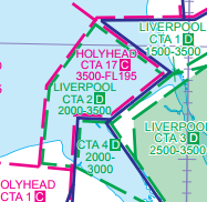
Where a piece of airport related airspace overlaps wholly with a piece of higher airspace, then an airspace base entry should only be made for the airport base (i.e. the lower one).
e.g. Holyhead CTA 17 (3500-FL195), and Liverpool CTA 2 (2000-3500)
- Here, only an entry for Liverpool CTA 2 should be made under Airports\EGGP\Airspace_Bases.txt
- The display settings for the profile will then need to be set accordingly so that EGGP Airspace Bases are turned on in addition to Airspace Bases, or nothing will appear in this area.
-
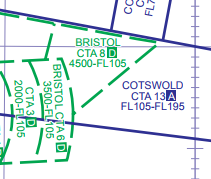
Where a piece of airport related airspace underlays part of a higher airspace section, the airspace base label(s) should be positioned accordingly.
e.g. Cotswold CTA 13 (FL105-FL195), and Bristol CTA 8 (4500-FL105)
- Here, there is an entry for Bristol CTA 8, and an entry for Cotswold CTA 13 that are positioned appropriately.
(right click, open the image in a new tab for a clearer view!)
- The differences between ARTCC Low and ARTCC High lines (dotted vs. filled) then make the distinction clearer.
- Here, there is an entry for Bristol CTA 8, and an entry for Cotswold CTA 13 that are positioned appropriately.
 (right click, open the image in a new tab for a clearer view!)